
|
|
|
 |
|
Thumbnails |
|
Slideshow (14 photos) |
| East Rosebud (map) |
The Ramp: Topping out on The Ramp -- the top of the 5.9 variation on pitch 5 |
||
The Ramp: At the top of the first pitch of The Ramp |
||
California Ice: Route description for California Ice |
||
California Ice: The first two pitches of the route -- each a rope-stretching 200 feet -- ascend this massive piece of ice |
||
California Ice: The lower section of the route as seen from the descent gully |
||
The East Rosebud canyon; there's a beautiful 5.10 route up the prow just left of center starting from the tree ledge |
||
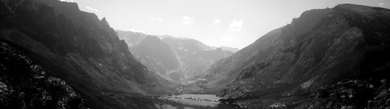
The East Rosebud Lake as seen from "The Hump" on the East Rosebud - Cooke City Trail; just past this hump is the drainage for California Ice |
||
California Ice: Starting the first pitch (WI4) of California Ice |
||
California Ice: The third pitch (WI3) goes to the right of the cave and up to easier ice |
||
California Ice: Joe climbs easy ice in the drainage below California Ice; we climbed about 2000' of easy ice to get to the base of the route |
||
California Ice: Around the final bend in the drainage we can finally see the main ice flow -- 400' of WI4 ice |
||
California Ice: Joe looks glum on the descent |
||
California Ice: Joe climbs the second pitch (WI4) in a snow squal |
||
Sand Dune Falls: Tommy and Joe take a rest at the base of Sand Dune Falls; unfortunately, the bottom portion of the route was missing -- she no go |
||
Returning from a failed attempt at Sand Dune Falls |

